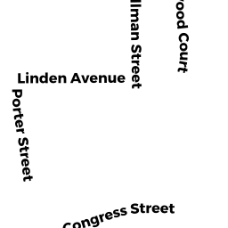
8 -10 PORTER ST
Owner Information
HARBORVIEW-PORTER REALTY TR
16 FRONT ST
BEVERLY, MA 01915


Property Details
8 -10 PORTER ST is classified as a Apartments with Four to Eight Units (Apt 4-8).
The primary structure on this property was built in 1920. There are 5,352ft2 of built area within this property. There is 5,352ft2 of residential/living space within this property. This property is listed as having 18 rooms. There are 6 units within this property.
8 -10 PORTER ST is valued at $1,015,400. The land is valued at $247,900 and the structures are valued at $767,500.
This property is in Zone R6. Confirm with local Zoning Board authorities to ensure there are no overlays or other easements on this property.
The most recent deed for 8 -10 PORTER ST is recorded at the local registrar in Book 8241, Page 322. 8 -10 PORTER ST was last sold on Tuesday, May 6, 1986 for $1.
Assessment data from fiscal year 2022.
Flood Data
According to the FEMA National Flood Hazard Layer, this property does not appear to be in a flood zone. It may also be in an area not yet reviewed. Nonetheless, confirm this information prior to taking any action.
To view the flood hazards around this property, create a FEMA "Firmette" Map of the area around 8 -10 PORTER ST.
Broadband Internet Providers
| Provider | Type | Bandwidth (mbps) | |
|---|---|---|---|
| Viasat Inc | Satellite | 100 | 3 |
| Comcast | Cable | 1000 | 35 |
| GCI Communication Corp. | Satellite | 0 | 0 |
| HughesNet | Satellite | 25 | 3 |
| VSAT Systems, LLC. | Satellite | 2 | 1 |
| Verizon New England Inc. | DSL | 10 | 1 |
Broadband service provider data from December 2020.
Adjacent Properties
- 6 PORTER ST
Apartments with Four to Eight Units owned by HILLTOP REALTY TRUST - 12 PORTER ST
Single Family Residential owned by MORRISSEY KARELLE A - 7 AGATE ST
Accessory Land with Improvement owned by FALLONI JOSEPH C JR - 9 AGATE ST
Single Family Residential owned by FALLONI JOSEPH C JR - 11 AGATE ST
Two-Family Residential owned by ELSO ADRIENNE J